

Natural Water Systems
Natural water systems refers to our watersheds, aquifers, streams and the Delaware River but also, for the majority of Solebury homeowners, their wells and water quality. Topics like watershed associations, floodplains, water-oriented recreation sources, etc. can be found here. The Township has differentiated on these water web pages between Natural and Domestic water sources to allow residents who use one or another quicker access to specific information.
Watersheds & Non-profit Associations
The Township has 10 watersheds or aquifers. To find your watershed, you can open two maps from the 2014 Comprehensive Plan. In the map section, Map No. 6, "Water Resources," and Map No. 7, "Aquetong Creek Watershed," indicate where these watersheds lie. Alternatively, you can visit the Township's Interactive Geographic Information System (GIS), locate your property, and click on the "Layers" tab in the upper left and select "Watersheds."

The complete list of watersheds from north to south is:
- Paunnacussing
- Copper Nose
- Cuttalossa
- Laurel
- An unnamed watershed that runs along Route 263 between Laurel and Primrose
- Primrose (see below)
- Neshaminy
- Aquetong (see below)
Honey Hollow - Pidcock
- Rabbit Run
- Dark Hollow
For further information on these watersheds, please refer to this link for the Primrose Creek Watershed Association: https://www.primrosewatershed.org/.
Two non-profit, volunteer associations manage active websites which record, on a regular basis, water quality tests and other items of interest. They welcome new volunteers and members.
Delaware River & Floodplains
You can open Map No. 6 in the Comprehensive Plan to see where FEMA has designated floodplains, or you can visit the Township's Interactive Geographic Information System (GIS), click on the "Layers" tab in the upper left and select "Flood Plains."
You can find Delaware River flood monitoring stations on the USGS website. Click here for the Stockton Gage, located beneath Bridge Street off of Upper York Road. From there you can use the arrows above the map to view upstream and downstream gages.
If you are in a river floodplain it is suggested that you make a notation where the flood waters came in the last event and reference this against the river's peak for that flood. In the future, you may be able to determine where a flood level may occur on your property, according to the USGS website's river flood forecast. The gages at Stockton and Riegelsville are good references for our area.
In-depth, up-to-date information, studies and activities covering the Delaware River include:
- Delaware River Basin Commission
- Lower Delaware Scenic River Wild & Scenic Group
- US National Parks Service
- Pa. Department of Environmental Protection (DEP)
Creek Maintenance
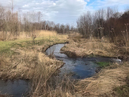 Solebury Township enjoys many creeks, all of which flow through private property to the Delaware River. The Township provides information for residents and watershed organizations which have creeks running through their property.
Individual property owners are responsible for creek bank and bed repair, maintenance, and appropriate permitting. Solebury’s creeks and their tributaries include the Paunacussing, the Copper Nose, the Cuttalossa, Laurel Run, the Primrose, Rabbit Run, the Aquetong, the Neshaminy, Dark Hollow Run and the Pidcock. With exception of the Neshaminy, the above creeks and tributaries predominantly drain to the Delaware River South Watershed.
Several state and federal agencies have jurisdiction over the creeks. Since creeks are considered “Waters of the U.S.” The Pennsylvania Department of Environmental Protection and the U.S. Army Corps of Engineers have the authority under the Clean Water Act (section 404) for activities such as placement of rip-rap (stone), placement of fill material, disturbance of stream banks, etc.
The creek channel is a dynamic environment, constantly changing, and erosion is a natural part of the creek's makeup. Some sections of creeks may require ongoing maintenance to keep erosion in check, while other sections may need riparian buffer upgrades and/or maintenance. Riparian areas directly adjacent to the creek banks should be maintained with trees and high grasses. These items help cool the waters in the creeks and filter out the sediment which is harmful to creeks. Care should be taken to avoid planting invasive species. The maintenance of creeks is the responsibility of the property owner and could require permitting from state and federal agencies, as well as Solebury Township.
Some activities that property owners do can be more harmful than helpful. For example, removing vegetation from the creek banks and mowing the lawn right up to the top of the creek bank is harmful to the creek’s health. Vegetation is vital to keep erosion to a minimum and long grasses intercept sediment that is carried by stormwater runoff. Routine maintenance of large trees is also an important activity that provides the shade for the creeks’ water and provides benefits with regards to reducing stormwater runoff. If trees are not maintained, fallen trees and tree limbs will block the stream flow and collect debris which can cause flooding during a storm event. Storing firewood close to streams is not advised. During flood events, firewood and other debris are easily swept away by water and subsequently create problems downstream: Debris clogs culverts and storm sewers. Solebury Township regularly hears about clogged culverts causing road and property destruction after almost every hurricane event in the recent years! On the other hand, and in the absence of flood danger, it is natural for the occasional fallen tree to remain in the water, which serves to dissolve and increase oxygen, reduce erosion and provide a pooling habitat for macro-invertebrates. Residents are encouraged to contact the state agencies and Solebury Township before starting any work in or around creeks.
Activities that DO NOT require Permits:
- Removal of trash and debris from creek banks or in creek beds.
- Minor Trimming of vegetation on the creek bank. Keep as much of the tree canopy as possible since the canopy provides shading for the creeks water and slows stormwater runoff.
- Planting bushes and trees along creeks. Do it!
Activities that DO Require Permits:
- Large scale debris removal.
- Vegetation or tree removal.
- Alteration of creek channel or its banks.
- Stabilization of creek banks.
- Dredging.
- Dumping of dirt, rocks, concrete, etc. into channel or eroded banks.
Recreation
- Delaware Canal Park
- Friends of the Delaware Canal
- Aquetong Spring Park Aquetong Spring Park preserves in a walking environment the Aquetong Spring, waterfall and cold-water trout stream. The history of this site can be discovered at the Solebury Township Historical Society's website, soleburyhistory.org.
Visit the Township's Parks & Recreation pages for complete recreational opportunities in Solebury.
Frequently Asked Questions
Frequently asked questions about water sources, quality, quantity and sustainability of our 11 aquifers or watersheds.
Which aquifer or watershed supplies my water?
Visit the Township's GIS map and click on the "Layers" tab in the top left corner. Select "Watershed" and "Parcel" from the list, locate your property and note the watershed name on the map.
How do I know the quality of my water?
For all private wells, residents must have their own waters tested, at their own expense, to determine quality and possible contamination problems. Water experts suggest annual testing. Filtering solutions and ultraviolet light scans are useful remediation tools. A fair generalization is that private wells are most likely to suffer from bacterial contamination if there is a problem.
How do I know the aquifer under our property has enough water to supply my well?
For private well customers, a well expert can run water flow tests on your well. Being aware of drought seasons or drought emergencies is important.
I would like to drill a new well or deepen an existing well. What do I need to know?
It is suggested that a professional well contractor should be up to date on the County and Township ordinances. The Township ordinances can be found in the Municipal Code, Water, Chapter 26. Wells specifically start at Ordinance 216 of May 18, 2004, Article II.